Abstract
Interest continues to grow in providing mobile services to unmodified handsets from satellites. These direct to device (D2D) systems would operate using a constellation of satellites in low Earth orbit (LEO) to supplement terrestrial mobile services. They could operate either within the mobile service (MS) or mobile satellite service (MSS) allocations. This could involve sharing with terrestrial services, either co-frequency or non-co-frequency. In order to protect these terrestrial services, it has been proposed that there be power flux density (PFD) limits that these D2D systems must meet. But an important questions is how to determine the PFD that these D2D systems could generate for studies within national, regional and international regulatory regimes. This White Paper shows how studies of the PFD generated by D2D satellite systems can be undertaken using the Visualyse Professional tool.
Background
A number of non-GSO satellite operators are proposing to provide services to unmodified handsets, including Apple, AST SpaceMobile, Globalstar, Lynk Global, Amazon’s Kuiper, SpaceX’s Starlink, Viasat, and Iridium. There is the potential for these services to cause harmful interference into existing services, whether co-frequency or non-co-frequency, including MS networks, MSS systems and other services including radio astronomy and the fixed service. In order to ensure compatibility between these systems, it is necessary to develop a regulatory framework that could include new allocations and constraints on D2D operators.
These are being studied under a number of agenda items (AIs) for the World Radiocommunication Conference (WRC) in 2027, in particular:
- AI 1.13: considers studies for a possible allocation to the MSS for direct connectivity between space stations and International Mobile Telecommunications (IMT) user equipment (UE) to complement terrestrial IMT network coverage
- AI 1.14: considers studies for possible allocations to the MSS around 2 010 - 2 025 MHz (Earth-to-space) and 2 160 - 2 170 MHz (space-to-Earth) in ITU Regions 1 and 3 and 2 120 - 2 160 MHz (space-to-Earth) in all regions.
At the international level, these topics are being considered at the International Telecommunications Union (ITU) Working Party 4C and at the regional level within groups such as:
- Asia-Pacific Telecommunity (APT)
- Arab Spectrum Management Group (ASMG)
- African Telecommunications Union (ATU)
- Caribbean Telecommunications Union (CTU)
- European Conference of Postal and Telecommunications Administrations (CEPT)
- Inter-American Telecommunication Commission (CITEL)
- Regional Commonwealth in the Field of Communications (RCC).
National regulators are also beginning to look into possible frameworks to allow licensing of D2D systems within their territory. An example would be a recent consultation document from the UK regulator, Ofcom: “Enabling Satellite Direct to Device services in Mobile spectrum bands”. Amongst other proposals out for consultation, is the suggestion that licence conditions could include the need to meet specific PFD limits.
But how to determine whether a non-GSO D2D system meets these PFD limits? One way this can be done is using the system characteristics and parameters to model their operation and calculate the resulting PFD levels. This requires detailed modelling and the ability to aggregate the PFD from potentially large numbers of satellites providing services to a deployment of UEs.
These are complex scenarios to model, but Visualyse Professional and Visualyse Interplanetary are designed to model just these types of systems and this scenario, as discussed below.
Protecting Terrestrial Services using PFD Thresholds
One way to facilitate sharing between terrestrial services and satellites services including D2D is the use of PFD thresholds. These specify the total power from one or all satellites as measured on the surface of the Earth. Two questions can then be addressed:
- What are the appropriate PFD thresholds to protect terrestrial services?
- Would the satellite service meet those limits while providing a usable service?
One way to derive a PFD threshold was described in the Ofcom consultation document, namely from an associated I/N ratio. The following equation can be used to calculate a threshold PFD level from a threshold I/N using:
Where:
k = Boltzmann's constant
= reference temperature of 290 K
= noise figure in dB
= bandwidth in Hertz
= threshold of the interference-to-noise ratio
= receive gain in direction of interest, for example, towards the satellite
= wavelength in meters.
= threshold level of PFD.
Other terms could be included, such as feed loss, body attenuation etc. The table below shows example calculations for two frequencies for interference into a low gain receiver such as the UE.
| Frequency (MHz) | 942.5 | 1950.0 |
| NF (dB) | 9.0 | 9.0 |
| Noise (dBW) | -135.0 | -135.0 |
| I/N (dB) | -6.0 | -6.0 |
| I (dBW/MHz) | -141.0 | -141.0 |
| Grx (dBi) | -3.0 | -3.0 |
| Wavelength (m) | 0.318 | 0.153 |
| Aiso = | -20.9 | -27.3 |
| PFD (dBW/m^2/MHz) | -117.0 | -110.7 |
In this case the PFD applies the aggregate over all satellites, but in other cases the PFD could be on a satellite per satellite basis. This is particularly the case where there is significant directivity at the receiver, such as at the base station receiver. In this case, the PFD could vary by elevation angle, as in the figure below.

While the Ofcom consultation document didn't give a threshold for the adjacent band, one could be derived using a suitable Tr(I/N). For example, with a Tr(I/N) = -20 dB, the resulting Tr(PFD) = -124.7 dBW/m^2/MHz.
With thresholds like these, the next question is then whether a D2D system would meet or exceed the PFD levels specified, as described in the following section.
Building the D2D Simulation
Scenario of Interest
The scenario of interest is shown in the figure below:

A D2D system is providing service to a deployment of UEs, which will create interference into terrestrial services, such as a terrestrial BS and UE. The PFD from this D2D system is calculated at a test point in an adjacent area. The PFD is calculated both co-frequency and non-co-frequent in the adjacent channel and as an aggregate and per satellite by elevation angle.
D2D Satellite System Parameters
As noted earlier, there are a number of non-GSO D2D systems currently being proposed, operating on a range of frequencies, including MS and MSS frequency bands. In addition, the technology is developing rapidly, and some systems have already iterated the parameters they propose to use.
The parameters considered here are based upon the MARS-ULS filing with some additional parameters from FCC documents. The orbit parameters are given in the table below:
| Number of planes | 48 |
| Satellites per plane | 110 |
| Altitude (km) | 350 |
| Inclination angle (deg) | 53 |
| Phase between planes (deg) | 1.6 |
The downlink parameters are shown in the table below using the n25 frequency band:
| Direction | DL |
|---|---|
| Frequency (MHz) (*) | 1990 |
| Bandwidth (MHz) | 1 |
| Satellite peak gain (dBi) | 34.8 |
| Satellite beamwidth (deg) | 3.2 |
| Satellite gain pattern | Bessel |
| Power control used | Yes |
| Target PFD (dBW/m^2/MHz) | -90 |
| Max Tx power (dBW) | 4.5 |
| Min Tx power (dBW) | -20 |
| UE peak gain (dBi) | -8 |
| UE gain pattern | Isotropic |
| UE noise temperature (K) | 1453 |
| Tr(C/N) (dB) | 2.5 |
| Calculated clear sky C/N (dB) | 11.5 |
(*) note that this frequency is not covered by the Ofcom consultation document.
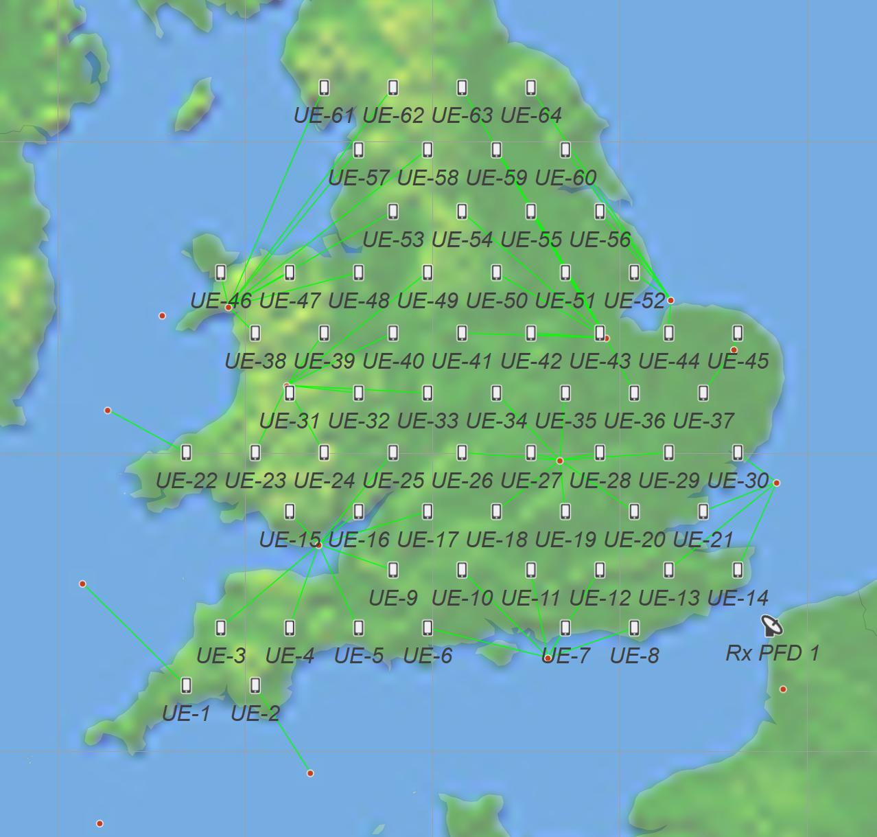
The UE’s were deployed ever 50 km across England and Wales, with the PFD test point in northern France, as in the figure below:

The satellite selection method was highest elevation angle from those at least 20° above the horizon.
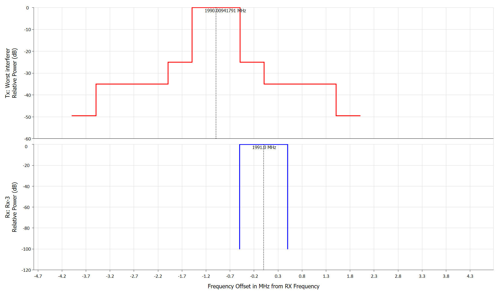
The transmit spectrum mask was derived from the limits in FCC part 25.202: “Frequencies, frequency tolerance, and emission”, as shown in the figure below:

The non-co-frequency PFD was calculated at a frequency of 1.991 GHz. The simulation was run for 100,000 time steps of 1 second duration under two cases:
- Not including Doppler or assuming perfect Doppler correction
- Including Doppler (using Visualyse Interplanetary).
Results
The table below shows the maximum PFD at the test point at the two frequencies considered, either taking Doppler into account or not:
| Maximum PFD | Co-frequency | Non-co-frequency |
|---|---|---|
| Threshold | -110.7 | -124.7 |
| No Doppler | -111.8 | -139.4 |
| With Doppler | -111.4 | -128.8 |
It can be seen that the PFD thresholds are met in all cases. The co-frequency results are similar whether Doppler is included or not, but including Doppler makes a significant difference for the non-co-frequency scenario. This relates to the frequency of the D2D satellite being shifted into the victim bandwidth, altering the net filter discrimination (NDF) as shown in the frequency view below:

The variation in PFD against elevation angle is shown in the figure below:

The PFD can be seen to exceed the Tr(PFD) for some elevation angles. This could require additional geographic separation or for this mode of operation not to be used i.e. avoid satellite downlink into terrestrial mobile uplink.
Conclusions
This document has shown how Visualyse Professional can be used to:
- Model D2D satellite systems in detail
- Calculate aggregate PFD taking into account multiple beams from a constellation providing a service to a deployment of UEs.
- Calculate both co-frequency and non-co-frequency PFD
- Calculate how PFD per satellite varies by elevation angle
- Analyse the impact of Doppler on the PFD calculated.
As well as undertaking analysis of the PFD generated by a D2D constellation, there will be other requirements for studies, such as:
- ITU studies under WRC-27 Agenda Items 1.13 and 1.14
- Coordination studies: to coordinate a new D2D constellation with other existing filings
- National regulation: a D2D system would require national licensing and if using spectrum licensed to terrestrial operators, will have to provide evidence that their operation would not cause them harmful interference
- Spectrum sharing methodologies: how to improve spectrum sharing so that a terrestrial operator could also use their spectrum for D2D systems most effectively.
With help of the Visualyse Professional tool, those with an interest in this subject, whether a non-GSO satellite operator, a terrestrial operator or national regulatory administration, can achieve their regulatory objectives.
